Lagoa do Fogo
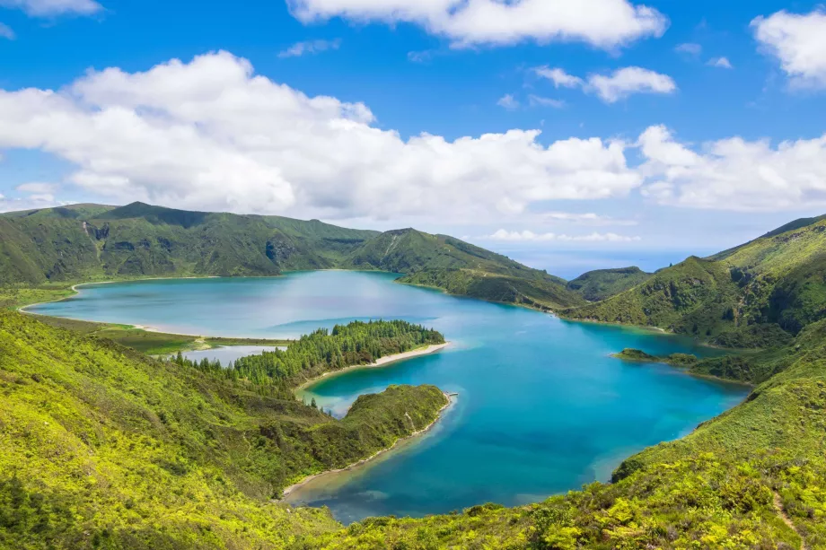
Lagoa do Fogo, the Lake of Fire, fills the now extinct and green crater of the Água de Pau volcano and with an altitude of 580 metres is the highest lake in the Azores. Lagoa do Fogo is generally considered the most beautiful lake in the whole of Portugal.
Choose a hotel in São Miguel with a discount
The lake was formed by an eruption in the 16th century, when an eruption created steep caldera walls on three sides that gradually filled with water, mostly from rainfall, which maintains the level to this day. Thanks to the suitable geological conditions, which partly act as filtration, Lagoa do Fogo is a source of drinking water for several municipalities on the island.
Views of the lake
Due to its location at the bottom of a crater, the lake attracts breathtaking views. The most famous view can be found right on the road passing through the pass above the lake, from where the whole of Lagoa do Fogo can be seen in the palm of your hand. This viewpoint is called Miradouro do Lagoa do Fogo (location on the map: en.mapy.cz) and you don't have to walk a metre to find it: you can park right at the viewpoint.
But in our opinion, a much more beautiful viewpoint awaits at the highest point in the area, the top of the 949-metre-high Barrosa Hill. A road passes through here too, and you can park in a small parking lot at the viewpoint (location on the map: en.mapy.cz), but you can also take a short hike along the asphalt road past the transmitters directly to the highest point of the hill (about 1.5 km round trip in total), where you won't be disturbed by passing cars while enjoying the wide view.
Walking around Lagoa do Fogo
From the parking lot at the Miradouro viewpoint to Lagoa do Fogo, descend 200 steep steps to the beach right at the surface of the lake and walk along its shores. However, due to the steep slopes, the lake cannot be circumnavigated all the way around, but only about one half.
However, if you don't want to drive to the lake, there is a marked and very popular hiking trail from the village of Praia - Água de Alto on the shore. The marked trail starts on a side road that disconnects from the coastal road (you must exit the highway at exit 13 from Ponta Delgada, or 14 from the other side).
The trail passes through a beautiful, dense green landscape of small valleys and coniferous forests, and although you'll be going uphill virtually the entire time, the elevation gain is not dramatic. In total, you'll walk a total of 11 km there and back (see route map) and expect to spend roughly 4.5 to 5 hours on the trail. There will be very frequent stops for photo stops. For more information about the route, check out the official tourist website of the Azores.
Landscape around the lake
The landscape around the lake is unique, with a specific microclimate that allows the presence of several endemic species of plants and animals. While the southern, eastern and northern sides of the lake are made up of steep caldera slopes covered with rich green grass, the mountains give way to a pass to the west, where the lake partially drains and where coniferous forests of valuable short-leaved junipers and laurel trees can be found.
The area around Lagoa do Fogo is also home to many species of birds.
Suitable conditions are created by the very frequent rain showers and the open slopes of the crater, which receive a lot of sunlight.
How to get to Lagoa do Fogo?
Is it possible to reach the lake by bus or by a long-distance walking route?
By car
The quickest and most comfortable way to get there is by car, along a mountainous and very winding but good quality road marked EN5-2A. This connects the towns of Lagoa (11km) on the south coast with Ribeira Grande (12km) to the north. The distance from Ponta Delgada is then 21 km, see route map.
Free parking is available at two viewpoints overlooking the lake. Be aware that the road is full of switchbacks and dangerous curves, so the journey will take a lot longer than you would expect looking at the distance. The turn off from the main roads on the south and north coast are clearly marked.
Compare car rental prices - PDL Airport
On foot
There's also a marked walking route to the lake from the south, which we describe above in the "Walking Around the Lake" section, but here you'll need a car to get to the start of it as well.
There are no buses to Lagoa do Fogo.
What to see around
Discover all the places to see in São Miguel.
Any questions left?
If you have any questions or comments about the article...

